Monday, June 6, 2016

Nassau, New Providence, Bahamas to Jacksonville, FL June 2 - 4

     After a few days at Atlantis, the Houston crowd had to return home, and Kay and I must return to the States.  Our plan had been to travel about half a day up to the Berry Islands on the day the kids/grandkids depart, then travel up to Grand Bahama Island the following day, and then do an overnight (2 days, one night) trip straight to Jacksonville, where the boat will hang out for most of the summer.  However, weather forecasters were calling for deteriorating conditions, and urging any who planned to travel this area to arrive at their destination no later than mid-day June 5, and preferably on June 4.  After some study and consultation, we decided to just travel non-stop from Nassau to Jacksonville, a 3-day, 2-night trip.  With just two of us aboard to stand watches, we try to generally travel only one overnight in each voyage, but sometimes the usual just needs to be adjusted.
     We put the kids and their luggage on the dock around 0900, and backed out of the slip.  They were going back to enjoy the water park again before departing for the airport mid-afternoon.  We cleared the Nassau Harbor, and headed for the north end of the Berry Islands, turning northwest toward West End, Grand  Bahama, about 1530.  By about 0330, after threading our way past many tankers and cargo ships in and around Freeport, we were exiting the Northwest Providence Channel and entering the ocean between the Bahamas and Florida.  After flying on Texas Ranger for 2 months, the Bahamas courtesy flag must come down.  After about 30 more miles of steering northwest, very definite northward drift from the current of the Gulf Stream was appreciated, and I turned more northward to maximize speed.  I had about 3.5 knots of current, and was sustained over 11 knots for many hours until it was finally necessary to again angle more northwest and exit the Gulf Stream.  On both nights the sky was mostly clear, with innumerable bright stars--a stunning sight.  There was some lightning visible both nights, but always over the horizon, with nothing close by. 
     At about 1000 June 4 we reached the entrance to the St. John River, which leads 25-30 miles upstream to Jacksonville.  We unfortunately were bucking some current, and various issues typical of Jacksonville (railroad bridge, river closure for a boat race, etc.) slowed our progress somewhat.  En route upriver, I cleared in with customs and immigration by telephone, having filed the requisite float plan and information before departing our last foreign port.  We arrived at our marina--Ortega Landing--just south of downtown Jacksonville and docked about 1500.  The trip, dock to dock, took about 54 hours, and we traveled about 438 nautical miles.  We will now retrieve our car from Fort Pierce, clean up the boat, batten down the hatches and ride out the anticipated tropical storm Colin, and thereafter return to Texas.  After four months aboard, I wonder how long it will take for the ground beneath our feet to stop moving?

Bahamas Courtesy Flag

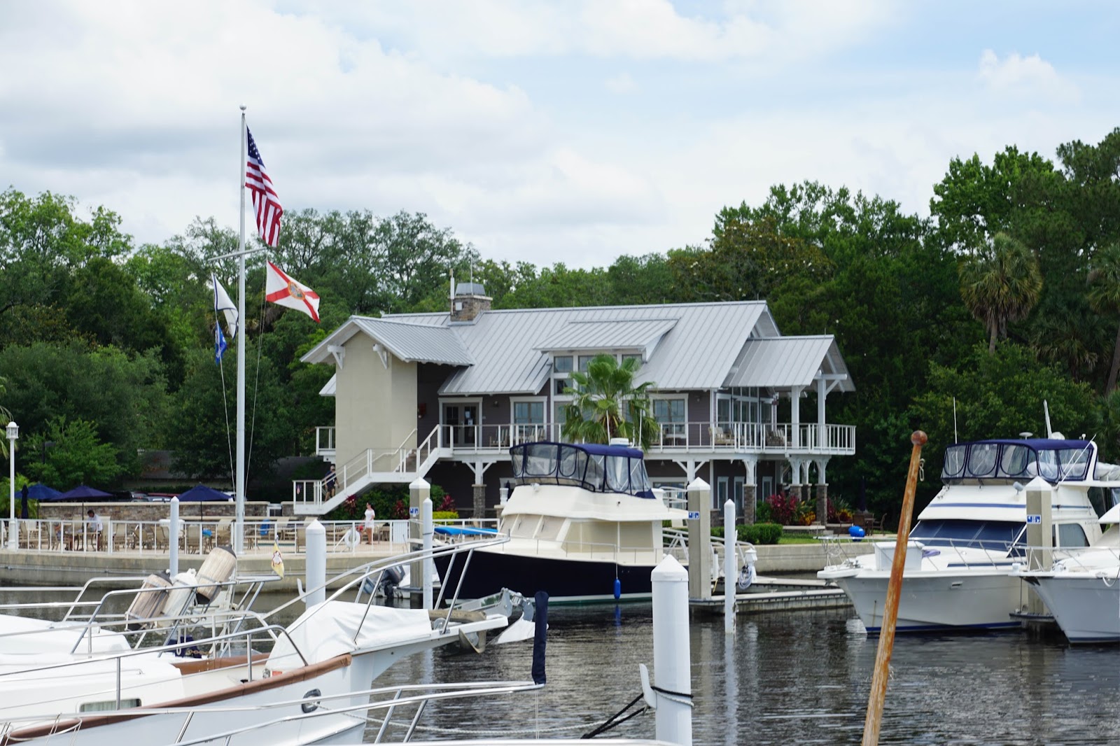
Ortega Landing Marina, Jacksonville, FL


Family Aboard May 26 - June 2

Concentration?
Ready for the Water Park


Atlantis

Atlantis, Nassau, Bahamas
Atlantis

     After spending one night aboard at Palm Cay, we headed out from New Providence Island for the Exumas to show the "kids & grandkids" the Bahamas.  We spent several days anchored at Norman's Cay, with trips to nearby islands and beaches, shelling, building sand structures, snorkeling, and just watching the scenery.  The little ones were in high gear until the crash point, then up and ready to go again the next day.  We were even treated to a fireworks display our last night at anchor.  It was staged by a large charter yacht that was anchored nearby, and which obviously staged it for their guests.
     All too soon it was time to move back toward civilization, so we traveled back to Nassau, this time docking at the marina at Atlantis.  Included in the dockage fee is admission to the water park and Atlantis facilities for all aboard...that in itself more than justified the rather expensive dockage rates.  All had a wonderful time exploring the many maritime exhibits, aquariums, water slides, water rapids to tube, and many other attractions.  One could certainly spend more time than we had available at this resort.


Palm Cay Marina, Nassau, New Providence May 23 - 26

     After several days at Spanish Wells, we returned back to Nassau to prepare for the arrival of daughter Kim and her family.  On the recommendation of several friends, we stayed at Palm Cay Marina on the southeast corner of New Providence Island.  This turned out to be a delightful spot, with employees who were attentive and polite, a courtesy car available for short runs to the grocery store, etc.  In contrast to many of the downtown Nassau marinas, it was quite secure.  It was a very protected harbor in the middle of a large condominium development with a gated (and manned) entrance.  In addition, each evening a gate was raised across the water entrance, preventing thieves from entering by boat.  This approach is evidently a common one downtown.  Of course, it would also prevent those who had not paid their marina bill from sneaking out in the middle of the night!
     On the day of Kim's arrival we rented a car, which allowed us to fully provision at a larger and slightly more distant grocery store than the one accessible in the loaner car.  In addition, we met the travelers at the airport, and the daily rental was only slightly more expensive than their cab ride would have been.  On the morning of departure I bought a little fuel and sequestered it in its own side tank, just as "insurance" that I had enough to return to Florida after their visit without worrying about running too low.

Security Gate, Palm Cay Marina, Nassau
 

Saturday, May 21, 2016

Dunmore Town, Harbour Island, Eleuthera May 20

     “Around the corner” from Spanish Wells, geographically, is an area often referred to as “The Hamptons of the Bahamas”…Harbour Island, and its settlement, Dunmore Town.  One of the larger cities in the Bahamas in years past, it has long been an up-scale retreat for the very wealthy.  Access is generally via a narrow and crooked passage through the reef known as Devil’s Backbone, and boaters are strongly advised to employ a local pilot should they venture there aboard their own vessels.  We elected to ride over and back aboard the fast ferry from Nassau, which stops in Spanish Wells on its way to Harbour Island, and returns late in the day via the same route.  The ferry ride itself was a fun excursion, like a large airliner with about fifteen seats across in each row.  We were entertained en-route by Sanford & Son re-runs!
     Arrival on the large, concrete government dock puts one in the center of town, and we hiked up and down the hills to see the town.  Up the spine of the island and across to the east lies the Atlantic coast, completely reef-encrusted, but with famous pink sand beaches.  Indeed, though difficult to appreciate in photos, there is a pink hue to the sand, much of it being comprised of coral.  The attached photo of mangrove roots gives understanding to why boaters seek out mangrove swamps in which to tie their boats during tropical storms and hurricanes.  Such root structure exits both above- and below-ground, and the thick branches and leaves provide an almost absolute windbreak.  The Piggly-Wiggly was quite colorful, and as is obvious in the photo, the truck-load of groceries delivered on the cargo ship was merely dropped on the front porch to be sorted, cataloged, and moved inside by the staff.  Not only were the homes colorful, but the churches as well.  Would you like us to contact some of these folks for service on your church decorating committee?

Fast Ferry

Dunmore Town, Harbour Island

Valentine's Marina
Fort Point Cottage, Dunmore Town
Safety First!


Dunmore Town


Dunmore Cottage, Harbour Island

Dunmore Town

Pink Sand Atlantic Beach

Mangrove Roots

Piggly Wiggly

I Go To The Pink Church

I Go To The Blue Church

I Go To The Yellow & Green Church

Hatchet Bay to Spanish Wells, Eleuthera May 19—22

      Our anchor was finally wrested from the grip of an old mooring which it had snared on the bottom of Hatchet Bay, and we exited the narrow entry cut out onto the Eleuthera Bank.  A couple of hours of running northwest brought us to Current Cut, between Current Settlement and Current Island, where we passed through the relatively narrow passage only a short time after slack tide.  This carefully timed arrival placed the ebb current with us instead of against us, but it was already flowing at about three knots.  It is known to peak at two- to three-times that velocity, making transit against it impossible by many slower boats such as our own.  Most sailboats, being somewhat underpowered, would make very slow progress even against the amount of current which we experienced.
      After another couple of hours traveling northeast, we entered the shallow south channel into the harbor at Spanish Wells.  This town is located on St. Georges Cay, but the name of the cay has almost become synonymous with that of this romantic-sounding port which has been in use for over 500 years.  We docked at Spanish Wells Yacht Haven, which is nearing completion of its rebuilding project.  Not only are the docks new, but also the offices, outdoor bar and restaurant, and shower facilities.  There are also several cottages on the grounds which are available for rental, and extensive landscaping is being completed as we are here.
     This charming town is far better maintained than most of what we have seen in the Bahamas.  They evidently reject government assistance and its strings, and operate much of the infrastructure in a somewhat communal manner.  Industrious people, they supply about 80% of the lobster and commercial fishery harvested in the entire country.  Almost everyone and everything here is somehow related to some member or other of the Pinder family.  Budda's (that's the way they spell it) is a fascinating local hang-out, with tables and a bar in the rear (behind the golf cart in the photo and a large, noisy caged parrot.  The kitchen is in the school bus out front, and food is available for on-site consumption, or as it is called in the Bahamas, "takeaway".  There are far more golf carts than automobiles, and the arrival of the cargo ship or mail boat is a community event.  EVERYTHING must arrive by such cargo ships, and all travel off the island is by boat of some type…either small water taxis or by daily large fast ferries from Nassau.


Harbor Entry, Spanish Wells

Spanish Wells Waterfront

Spanish Wells Yacht Haven

Spanish Wells Waterfront

Eleuthera Express Cargo Ship

View From Up The Hill

Spanish Wells Homes

Spanish Wells Pinder Home

Rent Your Place in the Sun

Spanish Wells Home

Buddas Snack Shack

Wednesday, May 18, 2016

Davis Harbour to Rock Sound to Governor’s Harbour to Hatchet Bay, Eleuthera May 15—18

     After a couple of days at Davis Harbour Marina, we headed north along the west coast of Eleuthera.  Our first stop, after rounding the tip of Cape Eleuthera and traversing Davis Channel, was Rock Sound Settlement.  There is a moderate amount of “town” here, but since we arrived on Sunday it was all closed up.  We did walk up the hill behind the town to see the Ocean Hole, a large and deep (over 600 feet) lake surrounded by rock walls that is connected deep underground to the Atlantic Ocean on the other side of the island.  We walked through the town, but found essentially nothing open.  We might have tarried another day, but the next day was Whit Monday, a holiday celebrated in the Bahamas with almost complete closure of businesses.
     Therefore, we moved on, with our next stop Governors Harbour.  This is a picturesque Bahamian town; probably the largest in Eleuthera, with colorful houses and more businesses than we have seen since Nassau. It is the center of governmental services in Eleuthera.  Unfortunately, the holding for anchoring is terrible, with just a thin layer of sand on top of hard-scoured bottom.  And, there is no dinghy dock or good place to land a dinghy!  We anchored in a cove south of the town where the bottom was supposed to be better, but did not find it so.  After a somewhat bouncy night, we toured the town and then decided to depart, as our anchorage was becoming exposed to rolling waves as the wind clocked more to the south, and heavier wind was in the forecast.  We continued to travel north up the west side of Eleuthera and saw a topography that is higher, and vegetation that is much lusher, than that in the Exumas.  The water, however, is not as clear and colorful as in the Exumas.  The island is very pretty and, from a distance, quite green.  One can see why it is more populated than some of the other islands of the Bahamas.
     Our destination was Hatchet Bay, and its accompanying settlement, Alice Town.  Hatchet Bay has an entrance between rock cliffs that is only about 80 feet wide, but once inside is roomy and completely protected.  We joined about six sailboats already present, and there was room for many more.  The wind did indeed blow briskly, but we had essentially flat water due to the protection of the harbor. 

Davis Harbour Marina

Davis Harbour Entrance

Ocean Hole, Rock Sound Settlement

Governors Harbour

St. Peters Anglican
Church, Govenors Harbour

The Whole Family

Hatchet Bay Entrance


Friday, May 13, 2016

George Town to Staniel Cay to Norman’s Cay Exumas to Davis Harbour, Eleuthera May 11—13

      We left George Town and traveled up the Exuma Sound in several thousand feet of water, fishing along the way and entering Dotham Cut at Black Point Settlement before proceeding up the Exuma Bank to anchor behind Big Majors Spot at Staniel Cay.  Friends and fellow-Texans on K-K 58 Casablanca and their daughter and son-in-law were there, and we had a good visit.  They formerly owned K-K 44 Santa Clara.  We cleaned (and ate some of) the mahi-mahi pictured below, and then sent the remains to the live vacuum cleaner who had been circling below awaiting the scraps!  The pigs and roosters were still at the beach, and their cacophony awoke us before 0600.

     The next morning we traveled north on the Exuma Bank to stop at Norman’s Cay, a spot we had deferred on our way south with the intention of visiting it while returning.  It offers a number of islands, beaches, and places to snorkel—including a mostly-submerged C-46 airplane that crashed with its load of drugs a number of years ago.  Beach fans, please note that on one small island shown, all you need is a cooler!  The shade and a bench upon which to sit are already present!  The captions are with apologies to Milton and Strait...

     The following morning at slack tide we snuck out the small Norman’s Cay Cut into Exuma Sound, left the Exuma Islands, and crossed over to the island of Eleuthera.  We are probably fewer than 100 miles from where Cristobal Colon landed in the New World (San Salvador Island) in 1492, but this is likely as close as we will travel to that historic spot.  I’m not sure there is much more there today than when he arrived over 500 years ago.  We are actually in a marina for the first time in three weeks! With actual Wi-Fi and electricity!  Tomorrow I will actually rinse the boat with fresh water, also for the first time in 3 weeks...


Fresh Dinner

Clean-up Crew

Paradise Found

Oceanfront Property

Our Latest Venture

Davis Harbour Marina

Marina Office